An article by Seung Kyum Kim (MDes ’16, DDes ’19) and Richard Peiser, Michael D. Spear Professor of Real Estate Development, analyzing how housing values in Miami‐Dade County have been impacted by storm frequency and intensity over the past three decades was recently published in the Journal of Flood Risk Management. “The Implication of the Increase in Storm Frequency and Intensity to Coastal Housing Markets” is available to read for free through Wiley Online Library.
Kim, Peiser analyze storm impact on housing values for Journal of Flood Risk Management
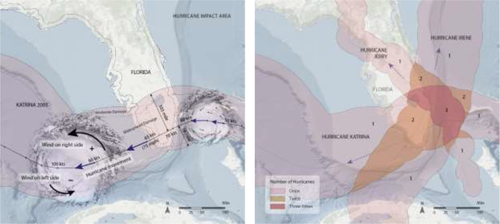
Hurricane influence (left) and frequency impact (right) areas illustrative map. Illustration by Kim and Pieser, source from NOAA (2018). Illustration by author; mapping source: Esri, DigitalGlobe, GeoEye, Earthstar Geographics, CNES/Airbus DS, USDA, USGS, AeroGRID, IGN, and the GIS User Community; NOAA